A watershed is a geographical unit in which the hydrological cycle and its components can be analysed. The equation is applied in the form of water-balance equation to a geographical region, in order to establish the basic hydrologic characteristics of the region. Usually a watershed is defined as the area that appears, on the basis of topography, to contribute all the water that passes through a given cross section of a stream.
The surface trace of the boundary that delimits a watershed is called a divide. The horizontal projection of the area of a watershed is called the drainage area of a stream at that cross section. The location of the stream cross section that defines the watershed is determined by the analysis.
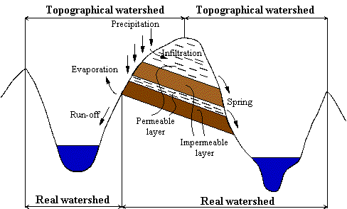
If a permeable soil covers an impermeable substrate, the topographical division of watershed will not always correspond to the line that is effectively delimiting the groundwater.
Figure 2.1. The difference between the real watershed and the topographical one [Musy, 2001]
Thus the watershed is different from the topographically delimited watershed. In this case it is called a real watershed. This difference between the two kinds of watershed is of particular importance in the karst areas.
In the delineation of a watershed artificial barriers (e.g. roads, railways) must also be taken into consideration. The hydrological process takes place especially on the surface, and it can be modified by artificial inflow (e.g. artificial derivation, drinking and wastewater networks, roads, pumps, reservoirs).
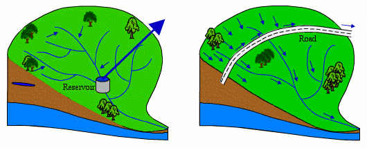
Figure 2.2. Artificial changes that occur in a watershed [Musy, 2001]
The conventional method of watershed delineation requires a topographic map. To start the divide we should start from the location of the chosen stream cross section, then we draw a line away from the left bank or the right bank always maintaining an angle of 90° to the contour lines. We continue the line until it is generally above the headwaters of the stream network. Finally we return to the starting point and we trace the divide from the other bank, eventually connecting it with the first line.
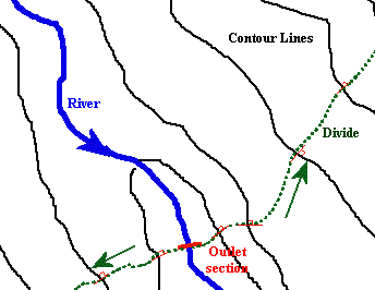 |
Figure 2.3. Watershed delimitation method - detail
The physiographical characteristics of a watershed influence to a large degree its hydrological responses and especially the flow regime during floods and periods of drought.
The concentration time, which characterizes the speed and intensity of the watershed's reaction to stress (rainfall), is influenced by the different morphological characteristics.
Watershed Surface
A watershed is the area of reception of the rainfalls and of supplying the
watercourse; the outlet flows depending thus on its surface. The surface of
a watershed can be measured using a variety of methods: superposing a grid over
the watershed map, using a planimeter or digitalizing methods.
Watershed Shape
The shape of a watershed influences the shape of its characteristic hydrograph. For example, a long shape watershed generates, for the same rainfall, a lower outlet flow, as the concentration time is higher. A watershed having a fan-shape presents a lower concentration time, and it generates higher flow.
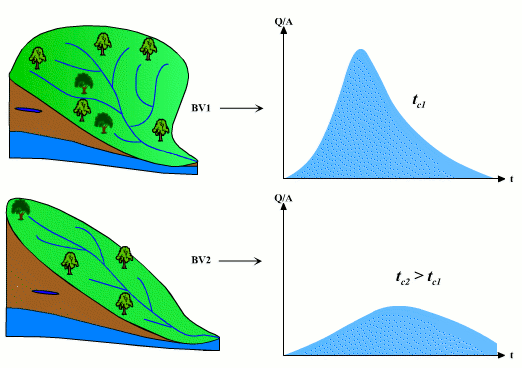 |
Figure 2.4. The influence of watershed shape on the hydrograph [Musy, 2001]
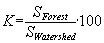
Different geomorphologic indices can be used for the analysis of a watershed if its shape is taken into consideration. The most frequently used index is the Gravelius's index KG, which is defined as the relation between the perimeter of the watershed and that of a circle having a surface equal to that of a watershed.
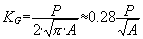 |
(2.1)
|
| where: | ||
| KG | Gravelius's shape index | |
| A | watershed area [km2] | |
| P | watershed perimeter [km] | |
Several values of the Gravelius's index for various shapes of watershed can be found in Figure 2.5.
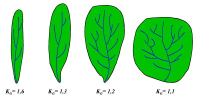 |
Figure 2.5. Some KG values for different watershed shapes [Musy, 2001]
Watershed orientation
The orientation of a watershed influences the melting speed of snow. Watersheds developed especially in North-South direction have an alternative exposure to sunrays; the melting speed of snow thus being smaller than in cases of watersheds developed towards East-West.
For a precise determination of the influence of watershed orientation, it is necessary to know the direction and frequency of the dominant wind.
The relief influences the reaction of the watershed through the following characteristics:
Watershed hypsographical curve
Watershed hypsographical curve gives a general synthetic view of the watershed relief. This curve represents the repartition of the watershed, taking its altitude into consideration.
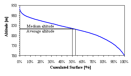
Figure 2.6. Hypsographical curve of a watershed [Musy, 2001]
The hypsographical curve has practical utility in the comparison of watersheds or of different sections of a watershed. The hypsographical curve also helps to establish the average amount of precipitation over the watershed, and can give information about the hydrologic and hydraulic behaviour of the watershed, and about its hydrographic network.
Characteristic altitudes for watershed
a) The extreme altitudes of the watershed, such as minimum and maximum, are obtained as a starting step for topographic maps. The maximum altitude is the elevation of the highest point of the watershed, while the minimum altitude is the elevation of the lowest point, this being generally the outlet section of the watershed. These values determine the altimetry amplitude of a watershed and help to calculate the slope.
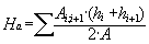
b) The average altitude of a watershed - can be deduced directly from the hypsographical curve or from reading the topographical map. The average altitude of a watershed is often used in the evaluation of certain hydro-meteorological parameters and can be calculated with relation 2.2.
 |
(2.2)
|
| where: | ||
| Ha | average altitude of the watershed [m] | |
| Ai;i+1 | area between two consecutive contour lines [km2] | |
| hi ; hi+1 | altitudes of the contour line [m] | |
| A | watershed area [km2] | |
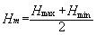
c) The medium altitude of a watershed, represents the arithmetic mean of the values of maximum and minimum altitudes of a watershed, and is expressed by the following relation:
 |
(2.3)
|
| where: | ||
| Hm | medium altitude of the watershed [m] | |
| Hmax | maximum altitude of the watershed [m] | |
| Hmin | minimum altitude of the watershed [m] | |
Watershed average slope
Watershed average slope offers information about the watershed topography. It is considered an independent variable. The average slope of a watershed influences radically the value of the time of concentration and, directly, the runoff generated by a rainfall.
Series of methods have been developed to estimate the average slope of the watershed. The method proposed by Carlier and Leclerc (1964) consists of calculating the weighted mean of all the elementary surfaces that exist between two contour lines. [Musy, 2001]
 |
(2.4)
|
| where: | ||
| ia | average slope of the watershed [m/km] or [‰] | |
| D | the equidistance between two consecutive contour lines [m] | |
| L | total length of the contour lines [km] | |
| A | surface of the watershed [km2] | |
The hydrographic network is defined as the sum of all the watercourses, natural or artificial, permanent or temporary, which contribute to the runoff. The characteristics of a hydrographic network of a watershed are influenced by four main factors: geology, climate, relief and environment. The hydrographic network is one of the most important characteristics of a watershed.
Hydrographic network topology
The classification of the watercourses was introduced by Strahler (1957). The order of the watercourses reflects the degree of ramification of the hydrographic network from upstream to downstream and it is based on the following principles: [Musy, 2001]
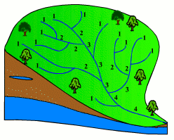 |
Figure 2.7. Strahler's system of hydrographic network classification [Musy, 2001]
Characteristic slopes and length for hydrographic network
The steep slope of a watercourse favours and accelerates the runoff, while a small slope gives the water the necessary time to infiltrate totally or partially into the soil. The calculation of the average slope is obtained from the longitudinal profile of the main stream and its tributaries.
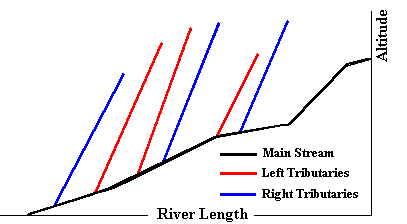 |
Figure 2.8. Longitudinal profile of a hydrographic network [Musy, 2001]
The most frequent method used to calculate the longitudinal slope of a watercourse consists of correlating the difference of altitude of the extreme points of the stream with its length.
 |
(2.5)
|
| where: | ||
| s1 | longitudinal slope of stream [m/km] or [‰] | |
| ΔH | difference of altitude of the extreme points of the stream [m] | |
| L | total length of the stream between its extreme points [km] | |
The degree of development of the hydrographic network
The degree of development of the hydrographic network, introduced by Horton, is given by the rapport between the total length of the hydrographic network and the watershed surface.
 |
(2.6)
|
| where: | ||
| Dd | degree of development of the hydrographic network [km/km2] | |
| Li | length of the stream [m] | |
| A | watershed surface [km] | |
The stability constant of a stream, introduced by Schumm, represents the opposite of the development degree of the hydrographical network.
Soil types and vegetal covering
The type of soil influences the infiltration rate, the retention capacity and the runoff coefficient. The humidity degree of the soil is one of the main factors that determine the concentration time. It is very difficult to measure this parameter because it has great variations in time and space. Most often other parameters are used. They reflect the soil moisture and can be obtained more easily. One of these is the antecedent precipitation index (API), expressed by the relation:
 |
(2.7)
|
| where: | ||
| API0 | the API initial values [mm] | |
| APIt | API values after t days [mm] | |
| t | time [days] | |
| K | regression factor (K<1), characteristic for each watershed and varies from one season to another [km] | |
The type and density of vegetal covering directly determines the quantity of water intercepted and retained by the soil. For example, the forest retains a certain part of the precipitation by the tree canopy. Vegetation regularizes the runoff in conditions that are meteorologically normal. Its action in extreme conditions (floods and droughts) is relatively reduced. In cases of soils without vegetation the capacity of water retention is reduced, which leads to torrential runoff and to apparition of riverbed erosion phenomena.
For estimating the influence of vegetal covering, a coefficient for various cultures must be calculated:
 |
(2.8)
|
Watershed geology
The geology of the watershed must be known in order to estimate the watershed hydrological reaction. The geology of the watershed substrate influences both the runoff and the groundwater flow. For the runoff the main geologic characteristic is the permeability of the soil substrate. In case of rainfall a watershed that has an impermeable substrate presents a faster and more violent increase of the runoff in comparison to a watershed with a permeable substrate. A watershed with a permeable substrate will provide a base runoff during dry periods that will last longer. Watershed geology is essential for groundwater flow, through the identification of the karst areas. These karst areas may modify even the real watershed delimitation.
The analysis of the hydrologic behaviour of a watershed is done in order to study the hydrologic reaction of the watershed in relation to rainfall. This reaction is measured by observing the quantity of water that is drained from the system. The graphical representation of the evolution of the discharge Q versus time is called a hydrograph. The hydrologic reaction of a watershed to a particular rainfall is characterized by its speed and its intensity. Figure 2.10 gives an example of a hydrograph resulting from a given rainfall.
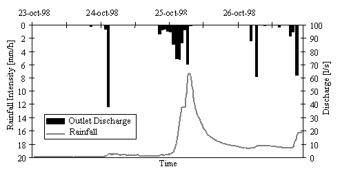 |
Figure 2.9. The hydrograph resulted from a rainfall [Musy, 2001]
The concentration time tc, of the water in a watershed is defined as being the maximum of duration necessary for a water drop falling on the watershed surface to reach the outlet section of the watershed. The concentration time is made up of three different terms:
Concentration time is thus equal to the maximum sum of the three elements:
 |
(2.9)
|
The concentration time may be deduced through field measurements or may be estimated with empirical formulas. [Musy, 2001]
The isochrone is a contour joining points of equal concentration time of the water in a watershed. The farthest isochrones from the outlet section represent the time passed for which the whole watershed surface contributes to the flow towards the outlet section after a uniform rainfall.
Thus, the tracing of the isochrones network allows partial the comprehension of the hydrologic behaviour of a watershed and the relative importance of each of its sub watersheds. [Musy, 2001]
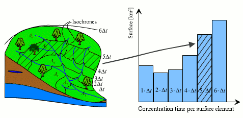 |
Figure 2.10. Representation of isochrones from a watershed [Musy, 2001]
These curves allow, for different hypotheses, the determination of the hydrograph resulting from rainfall over the watershed.
Dingman, S. L. 1994. Physical Hydrology. Pearson Education Ltd., London, United Kingdom.
Musy, A. 1998. Hydrologie appliquée, Cours polycopié d'hydrologie générale, Lausanne, Suisse.
Musy, A. 2001. e-drologie. Ecole Polytechnique Fédérale, Lausanne, Suisse.
Shaw, E. M. 1988. Hydrology in practice. Van Nostrand Reinhold International, London, United Kingdom.