(6.1)
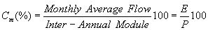
Stream hydrological regime is defined by means of flow variations, usually represented by the monthly average flow graphics (calculated for a certain number of years). Monthly flow coefficient is the monthly rapport of the inter-annual, which allows repartition representation, in percents, of the monthly flows during the year.
The hydrological regime of a stream is defined by the flow variations usually represented by the monthly average flow graphic (calculated for a certain number of years and called inter-annual module- rainfall):
|
|
(6.1)
|
It can be defined as the annual flow coefficient:
 |
(6.2)
|
The curve of monthly flow coefficients shows the systematic character of seasonal variations and compares the streams between them.
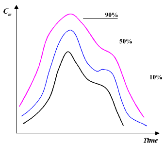 |
Figure 6.1 Examples of average flow curves [Musy, 2001]
Average annual flow can be represented by the following relation:
 |
(6.3)
|
A simple classification of hydrological regimes has been done by Pardé (1933), who distinguished three regime types:
In a first step two flow types can be distinguished: "rapid" flows (surface and subsurface flow) and "slow" flows (groundwater flow).
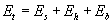
The annual flow Et represents the water quantity that flows every year through a basin. Total flow can be expressed by means of the following relation:
 |
(6.4)
|
| where: | ||
| Es | superficial flow | |
| Eh | hypodermic flow | |
| Eb | base flow | |
For important rainfall Es >> Eh. For this reason when it cannot always be distinguished quantitatively on the field, Es and Eh, is often adopted:
 |
(6.5)
|
| where: | ||
| Cr | surface flow coefficient | |
 |
||
| Ces | superficial flow coefficient | |
 |
||
| P | rainfall | |

Figure 6.2 Rain heights repartition during a shower of constant intensity [Musy, 2001]
Overland flow is a phenomenon that appears when the rain intensity exceeds the soil's maximum capacity to absorb water. This capacity decreases in time until it reaches a constant value. In homogenous soils, with a deep underground layer, this maximum capacity is equal to the hydraulic conductivity at saturation. Natural soils with an increased hydraulic conductivity in temperate and humid climate have an infiltration capacity inferior to the maximum intensity of rain.
Otherwise the flow process is developed in two phases:
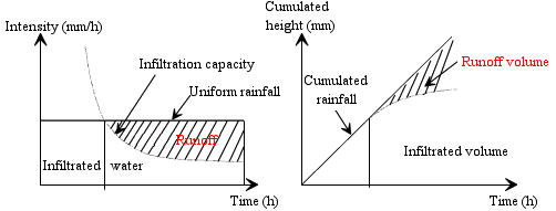 |
Figure 6.3 Infiltration rate and cumulate infiltration
for a uniform
rain and submersion time definition [Musy, 2001]
When the runoff process exceeds the infiltration capacity water flows into another area of the watershed with a superior infiltration capacity. Using mathematical models and site experiments, the resultant runoff process explains the hydrological basin's answer in semi-arid climates and also in conditions of important rainfall intensity.
The flow on saturated surfaces is produced when it exceeds the soil capacity to retain water and the capacity to transmit laterally the water flux. Figure 6.4 shows these two situations: flow on saturated surfaces and flows that exceed the infiltration capacity .
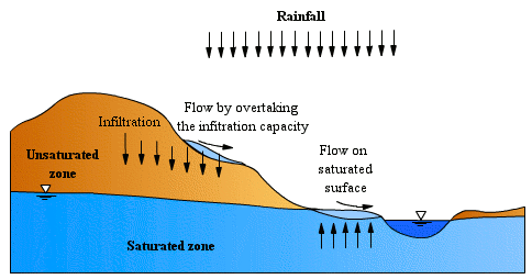
Figure 6.4 Flow process generated through
exceeding the infiltration capacity
and through flows on saturated surfaces [Musy, 2001]
Generally the flow is indirectly estimated from the hydrographical network.
Part of the infiltrated effective rainfall circulates more or less horizontally in the superior soil layer and appears at the surface through drain channels. This flow is called subsurface flow (in the past it was called hypodermic flow). The presence of a relatively impermeable shallow layer favours this flow. Subsurface flows in water bearing formations have a drainage capacity slower than superficial flows, but faster than groundwater flows. The essential condition for the appearance of the subsurface flows is: the hydraulic lateral conductivity of the environment has to be superior to the vertical conductivity. The subsurface flow in unsaturated regimes can be the base flow in the area with large slopes, and it is dominant in humid regions with vegetal covering and well-drained soils.
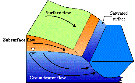 |
Figure 6.5 Different flow types [Musy, 2001]
Piston effect permits analysis of the subsurface flow. The existence was assumed of a mechanism to transmit a quasi-instantaneous pressure wave. This mechanism, called "the piston effect" assumes that water that falls on a slope is transmitted downstream with a pressure wave and causes a sudden exfiltration on the watershed.
This phenomena principle can be explained by analogy with a saturated soil column to which known quantity of water is added. Due to the gravitation effect water moves to the bottom of the column.
Macro pores are pores in which the capillarity phenomena are inexistent.
The origin of macro pores
We can distinguish:
Subsurface flow is carried through macro pores. Which lead the water to unsaturated areas.
Pipe flow emphasizes soil drainage and water flow. It is difficult to establish the exact difference between pipes and macro pores. Pipes are considered to be larger than macro pores. Also pipes present a higher connectivity degree than pores, without saying that the pipes are forming a continuous network. Pipes lead the water to an unsaturated environment.
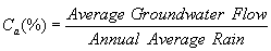
Since the aeration zone has enough humidity to allow deep-water infiltration a part of the rainfall penetrates into the phreatic layer. The amount of water depends on the underground structure and geology and also on the water volume that comes from rainfall. The water flow passes through the aquifer with a speed of several meters per day before it returns to the stream. This flow, wich comes from the phreatic layer, is called base flow or groundwater flow. The groundwater flows generally maintain stream discharge in the absence of rainfall.
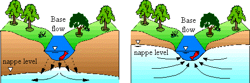 |
Figure 6.6 Two distinct situations in which
the underground layer can contribute
to stream discharge or drain the stream [Musy, 2001]
Darcy's Law and the continuity
principle govern the non-steady state movement of water in the ground. For the
difference between inflow and outflow, the following equation can be written:
Inflow = Outflow +/- Variation in Storage
The flow resulting from ice and snow melting dominates generally in glaciers and mountain regions, where the climate is cold. The snow melting process reloads the water layer and also saturates the soil. In some cases it can contribute to the surface flow. The increase in the surface flow will depend on water equivalent to snow or ice layer, on the melting regime, and finally on the snow's characteristics.
Alluviums are particles of different shapes and dimensions transported by the stream current. They come from the soil layers, from the slopes and also from the ground of the streambed. The alluviums from slopes are gravel and small boulders disintegrated by the hitting of raindrops or other atmospheric agents and they are carried to the streambed by overland flow.
The solid transport is the sediment quantity (or solid discharge) transported by the stream. This phenomenon is regulated by two stream properties:
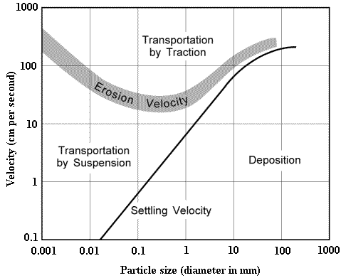 |
Figure 6.7. Hjulstrom diagram shows the competence
depending on water speed [Musy, 2001]
These two properties are not directly connected. The silt transport of a water stream is determined by the particle characteristics (shape, size, concentration, the drop speed and particles density). These allow us to determine:
Notions about specific transport and mechanical erosion on watershed
The notion of specific transport and mechanical erosion on watershed regroups two different processes. These two notions show the difference between the processes of alluvium detachment and transport, before going back into the stream, and also the transport into the stream.
The first notion concerns erosion agents, which are rain, wind, flow and also factors that condition the quantity of dragged particles: rain characteristics, soils, vegetation, topography and human activity. The quantity of dragged particles will be also determined by a number of factors like water speed, streambed characteristics, aggregate grading. Bank erosion can contribute to the suspension load measured in streams, and the presence of lakes and reservoirs leads to particle sedimentation. The sedimentation of solid matters transported by a stream is introduced into the reservoir. And to the downstream of dams erosion of the streambed takes place.
The following aspects emerge out from the second notion:
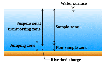 |
Figure 6.8. Classification of different types of riverbed sediments [Musy, 2001]
Musy, A. 1998. Hydrologie appliquée, Cours polycopié d'hydrologie générale, Lausanne, Suisse.
Musy, A. 2001. e-drologie. Ecole Polytechnique Fédérale, Lausanne, Suisse.
Shaw, E. M. 1988. Hydrology in practice. Van Nostrand Reinhold International, London, United Kingdom.
Vladimirescu, I. 1984. Bazele hidrologiei tehnice. Ed. Tehnica, Bucuresti, Romania.